Create a Customized Map
We will be creating maps showing where each sign was found. We will do so using google maps and the traffic sign photos we uploaded to flickr.
First, here is a video that gives a nice overview of how to make your own map.
First, here is a video that gives a nice overview of how to make your own map.
Here are the steps:
Go to Google Maps and select “My Places” (one person needs to be signed into their school google account).
Click the button “create map”.
Give it a title in the form of the location name and “traffic signs” (i.e. Framingham Traffic Signs).
In the description, list the date(s) on which you toured the area and that this map details the traffic signs you saw en route. For the time being, make the map “public”.
Click Collaborate and add the school-assigned email addresses of each group member plus the teacher.
Use the zoom-in feature to get to a readable map of the area in which you traveled.
Draw the route on the map, using the “draw a line along roads” button which looks like this
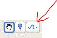
The red arrow is pointing to the "draw a line along roads" icon.
In a separate tab, sign-in to our flickr page. Select the first sign that you would like to use in the map.
Click on the “small“ size of the photo.
Right-click to “copy this link’s location”.
Go back to the your customized Google Map.
Zoom in unto you can easily pinpoint where that sign belongs.
Add a place marker (looks like a blue balloon)
In the dialog box that opens up, give the sign a title (for example: “do not enter”).
Click on the image icon (looks like a picture frame) and right-click in the text-box.
Select “paste” from the drop-down menu and then click “ok”.
Continue through the map, adding the images and locations of the traffic signs you located.
Save your map!
We will soon be embedding your map into our classroom website!